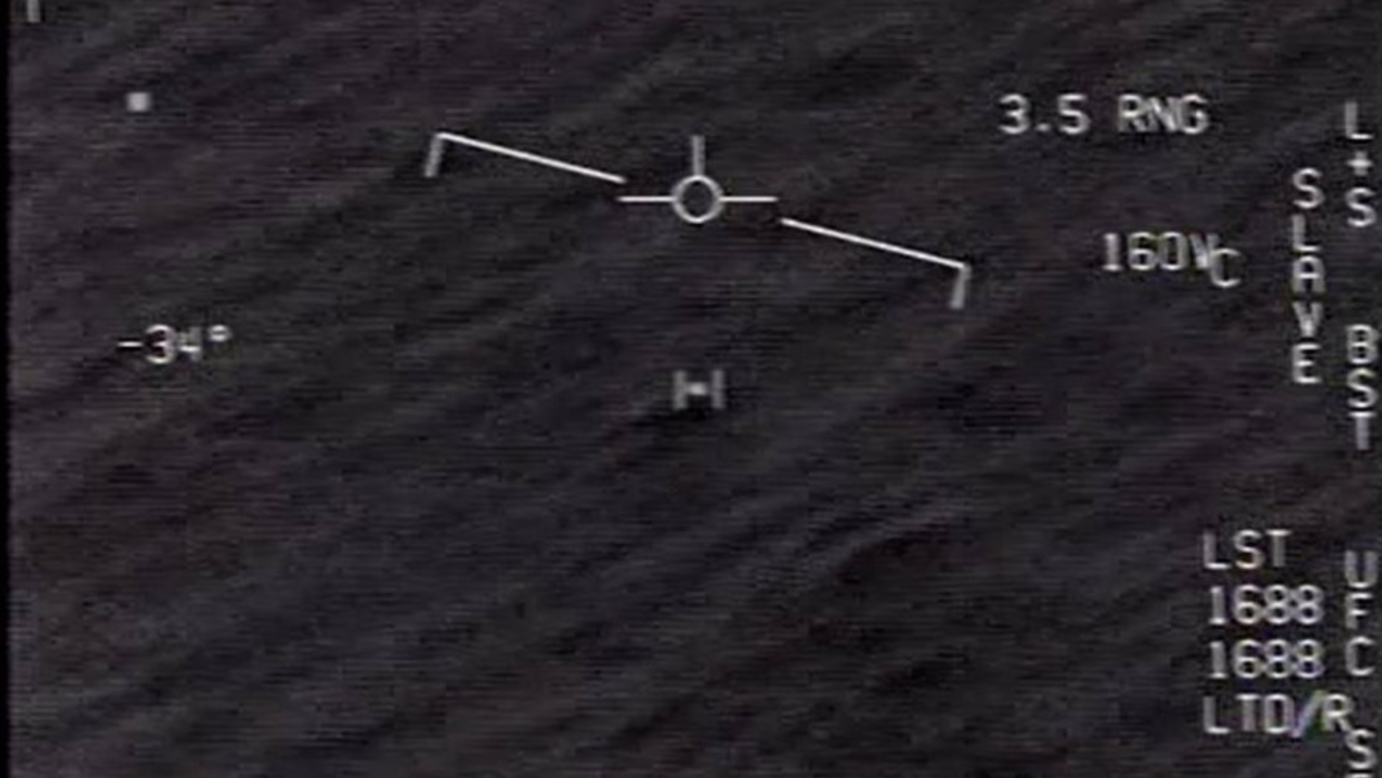
The GOFAST recording appears to show an object racing above the ocean. Estimating its real motion, however, requires more than watching pixels cross a screen.
A small dark object stays near the centre of the 2015 GOFAST infrared video while the ocean seems to sweep past beneath it. Recorded by the aircrew of a US Navy F/A-18F off Florida’s Atlantic coast, the clip is striking—but it does not directly display the object’s speed, size or altitude.
The Department of Defense released the video publicly in 2020. In February 2025, the All-domain Anomaly Resolution Office (AARO) published a case assessment and detailed methodology. It could not identify the object, but assessed with high confidence that it showed no anomalous performance. AARO’s GOFAST case resolution.
What the recording actually contains
GOFAST is a 34-second Forward-Looking Infrared, or FLIR, recording. Its bright and dark areas represent infrared contrast and do not reveal composition. The flight and sensor readouts provide more analytical value than appearance alone. Watch the official video.
| Information visible in the display | Why it matters | Important limitation |
|---|---|---|
| Range from sensor to target | Constrains the object’s distance from the aircraft | It is slant range, not altitude, and is displayed with limited precision |
| Sensor azimuth and elevation | Defines the camera’s line of sight | Small angular errors affect the reconstructed position |
| Aircraft altitude and speed | Describes the observer’s movement | The exact geographical position and compass heading are missing |
| Aircraft bank angle and elapsed time | Helps reconstruct the jet’s curved flight path | The calculation still depends on assumptions about motion between frames |
A video records a changing line of sight. Converting that into three-dimensional motion requires reconstructing where the camera was, where it pointed and how both camera and target moved.
Why “fast on screen” can be misleading
Motion parallax occurs when an observer’s movement changes the apparent position of objects at different distances. From a car, a roadside post seems to rush backwards while a distant hill barely moves. Neither impression gives the object’s real speed.
During the 13-second section used in AARO’s calculation, the F/A-18F was travelling at approximately 190 metres per second and banking at about 14 degrees. As it turned while the sensor tracked the object, the image combined the jet’s motion, the changing camera angle, the object’s motion and the ocean background.
AARO attributed GOFAST’s dramatic appearance to parallax. That conclusion rests on its reconstruction, not on the visual impression alone. Read AARO’s methodology.
Distance turns an angle into a speed
The same angular movement can represent very different distances. A one-degree change close to the camera spans a shorter path than it does at great range. An incorrect distance therefore produces an incorrect speed.
AARO analysed a segment in which the displayed range fell from 4.0 to 3.4 nautical miles. It combined those readings with the sensor angles and the aircraft’s altitude, speed and turn. The reconstruction placed the object at approximately 13,000 feet—not near the ocean surface as the video can appear to suggest.
The basic relationship is simple:
speed ≈ change in reconstructed position ÷ elapsed time
Establishing both positions is the difficult part. AARO compared frames 13 seconds apart, reconstructed the aircraft’s curved path and tested different headings and winds.
Why the result is a range, not one number
The public file does not include the F/A-18F’s exact location or compass heading. AARO therefore modelled the full range of possible headings and used historical wind data near the reported time and location.
The resulting ground-relative speed ranged from approximately 32 to 72 metres per second, or 72 to 161 miles per hour. After removing the wind’s contribution, AARO calculated an “intrinsic” speed—the object’s movement relative to the surrounding air—of approximately 2 to 41.3 metres per second, or 5 to 92 miles per hour. None of its simulations required the object to travel against the wind. See the reported speed ranges.
These modelled ranges depend on the displayed values, reconstructed flight path and wind estimate. AARO judged that the object did not demonstrate anomalous performance while leaving it unidentified.
That distinction matters: unidentified describes an unresolved identity; anomalous performance describes motion that available conventional explanations cannot account for. A case can meet one description without meeting the other.
What the analysis cannot establish
AARO worked from a compressed .wmv file because the original recording and accompanying metadata were no longer available. The display supported estimates, but limited precision and missing georeferenced aircraft data prevented a single absolute trajectory.
The low resolution and viewing distance also prevented AARO from determining size. Pixel analysis by an Intelligence Community partner suggested one metre or less—comparable to a small drone or bird—but that was an estimate, not an identification. AARO also said it sought but did not obtain accounts from the aircrew. See AARO’s data-quality limitations.
Publishing the methodology exposes its assumptions for examination. It does not restore missing data or turn possible solutions into certainty.
The wider lesson for UAP evidence
A video can establish that an event was recorded. With reliable telemetry, it may constrain altitude, direction and speed. Alone, it rarely establishes size or origin.
A stronger record would preserve the uncompressed file, sensor metadata, aircraft position and attitude, calibration, weather data, witness accounts and corroborating radar or other sensor records. Those materials allow competing explanations to be tested.
GOFAST remains unidentified in AARO’s assessment. Its scientific value lies in showing why the most important evidence in a UAP video may be the information around the image—and why uncertainty should be calculated, not edited out.